


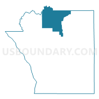
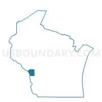
FARMINGTON - T 1 Voting District, La Crosse County, Wisconsin
About
Outline

Summary
| Unique Area Identifier | 694529 |
| Name | FARMINGTON - T 1 Voting District |
| County | La Crosse County |
| State | Wisconsin |
| Area (square miles) | 38.13 |
| Land Area (square miles) | 37.96 |
| Water Area (square miles) | 0.17 |
| % of Land Area | 99.56 |
| % of Water Area | 0.44 |
| Latitude of the Internal Point | 44.04683060 |
| Longtitude of the Internal Point | -91.15131600 |
Maps

Graphs
Select a template below for downloading or customizing gragh for FARMINGTON - T 1 Voting District, La Crosse County, Wisconsin


Neighbors
Neighoring Voting District (by Name) Neighboring Voting District on the Map
- FARMINGTON - T 2 Voting District, La Crosse County, WI
- GALE - T 2 Voting District, Trempealeau County, WI
- HAMILTON - T 3 Voting District, La Crosse County, WI
- HOLLAND - T 3 Voting District, La Crosse County, WI
- HOLLAND - T 4 Voting District, La Crosse County, WI
- MELROSE - T 1 Voting District, Jackson County, WI
- NORTH BEND - T 1 Voting District, Jackson County, WI
- ONALASKA - T 6 Voting District, La Crosse County, WI
Top 10 Neighboring County Subdivision (by Population) Neighboring County Subdivision on the Map
- Onalaska town, La Crosse County, WI (5,623)
- Holland town, La Crosse County, WI (3,701)
- Hamilton town, La Crosse County, WI (2,436)
- Farmington town, La Crosse County, WI (2,061)
- Gale town, Trempealeau County, WI (1,695)
- North Bend town, Jackson County, WI (488)
- Melrose town, Jackson County, WI (470)
Top 10 Neighboring Unified School District (by Population) Neighboring Unified School District on the Map
- Holmen School District, WI (19,240)
- West Salem School District, WI (9,747)
- Galesville-Ettrick-Trempealeau School District, WI (8,595)
- Melrose-Mindoro School District, WI (4,393)
Top 10 Neighboring State Legislative District Lower Chamber (by Population) Neighboring State Legislative District Lower Chamber on the Map
- Assembly District 94, WI (62,641)
- Assembly District 92, WI (58,894)
- Assembly District 91, WI (56,636)
Top 10 Neighboring State Legislative District Upper Chamber (by Population) Neighboring State Legislative District Upper Chamber on the Map
Top 10 Neighboring 111th Congressional District (by Population) Neighboring 111th Congressional District on the Map
Top 10 Neighboring Census Tract (by Population) Neighboring Census Tract on the Map
- Census Tract 102.01, La Crosse County, WI (9,503)
- Census Tract 101.01, La Crosse County, WI (5,566)
- Census Tract 9604, Jackson County, WI (4,268)
- Census Tract 1008, Trempealeau County, WI (3,670)